|
36. Asbury Park The Westside From Asbury Avenue to Deal Lake: Asbury Park High School and West Sunset Avenue, Part 1
Now for the northern border of Asbury Park. We've already had a decent look at the top (eastern) part of the northern border, which includes the main basin of Deal Lake, the Monte Carlo Pool, the panoramic view of the across to Loch Arbour, etc. Therefore, we're going to start at West Main Street, near the RR tracks, and work our way further west. Some of the most beautiful views are available in this part of town.
Image 1.36.3. Asbury Park High School. Asbury Park High School opened in 1927. In appearance, APHS is a great example of a traditional American high school: neoclassic architecture resting solid on tree-shaded Sunset Avenue, with an arched stadium. Its grounds are on the south branch of Deal Lake, just across the RR tracks.
Image 2.36.3. Asbury Park High School and grounds from the air. To the right is the tip of Wanamassa, in the foreground is Interlaken. Main Street is at left. The Atlantic Ocean is visible at the upper left-hand corner and the tiny western tip of Sunset Lake sticks out about an inch below that (okay, I touched up Sunset Lake a bit to make it more visible). I did my four years at APHS. As I've already said, school was not one of my favorite things (to put it mildly). Therefore, most of my really good memories come from private aesthetic experience and observation. We lived about four blocks south of the school and about one block west. Usually, I would walk to school - even when it was cold (though on really cold and snowy days my mother would drive me there). Walking gives you a "micro" perspective on things: The character of the slate sidewalk slabs, the bumpy roots of trees, weary old fences in peoples backyards - all of these elements become part of the adventure. Leaving our house, I'd amble up little New Street to Third, make a left and a quick right on narrow Bridge Street. I'd stay on Bridge for its length (three blocks), after which I'd reach Sunset Avenue, Deal Lake and, well ... the bridge.
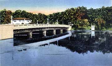
Image 3.36.3. The Sunset Avenue or "Wanamassa Bridge." In this image, Wanamassa is on the other side. I call it the Wanamassa Bridge because it leads to Wanamassa, just west of this town's peninsular tip. Its official name (I think) is the George W. Rosenstiel Bridge (named in honor of a highly regarded local), but nobody calls it that either. I guess most people call it the Sunset Avenue Bridge. It is one of three charming smaller spans that lead to our little peninsular towns. (The other little bridges are the Allenhurst-to-Interlaken Bridge and the West Allenhurst-to-Interlaken Bridge.) Just to the east of the Bridge (to the right foreground in the above picture) is Sunset Landing. This is a little rustic restaurant with a wood-beamed ceiling, spruce paneling and a fireplace. You can rent canoes there and paddle all over Deal Lake. Geese wander around in front. Through the years, many "regulars" from Asbury or the neighboring towns met to "shoot the breeze" with Chuck Logdon, the owner. The place has been around in one form or another since the 1890s.
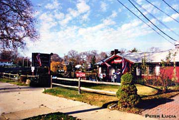
Image 4.36.3. Sunset Landing, Dec. 2001. To the left, in shadows, is the bridge. Asbury Park High School is two blocks east of Sunset Landing. Let's examine the High School area a bit more and indulge in a little history. There's a really pretty photo coming up.
[Tour Index Page] [Asbury Index Page] [Main Page]
|